
FORWARD to Ordnance Survey House Style, 1963
Reference numbers in square brackets and artists' initials are explained here
Ordnance Survey of Great Britain standard cover design, 1940 [1]
Martin created this design, featuring a border of wavy lines, usually with the “Medallion” Royal Arms, for the One-inch New Popular Edition planned for publication in 1940. It became the first standard post-war cover design. The medallion’s first known appearance was in blue on the Ordnance Survey 1937 Christmas card. It was redrawn on new post-1953 covers. Most covers are on cream card. Quarter-inch and Scotland One-inch maps retain hinged covers. N.B. See No 194
96.1 Red border
96.1.a “Medallion” Royal Arms
96.1.a.1 With hand-lettering EM One-inch Great Britain New Popular Edition, 1940 [published 1945]: sheets 157, 158, 161, 167, 169, 171, 172, 179, 182, 183, 184 only. Sheet 179’s cover was drawn first with “National Grid” below the medallion
- [a] 120x201mm 11840. (1945) KA1,(See Andrews, Sheetlines 76.p14-28 & 82.p17-21)
- [b] 123x204mm 11040. (1945) KA1,Hinged cover for dissected map.


96.1.a.2 In letterpress One-inch Great Britain New Popular Edition, 1945 [17] “Ten Mile” Map of Great Britain, 1962-1963
- [a] 123x209mm (Standard size) 1158. (11/47) Cloth map, Title on spine KA2, Three-box sketch.
- [b] 125x209mm (Standard size) No print code (1945) KA2-Hinged cover for dissected map.
- [c] 1157 (7/47) KA2-Paper map, No title on spine
- [d] 1025 (8/47) Cloth map, Title on spine KA3,Two-box sketch,"New Popular Edition" in large print, "SHEET".


- [e] (9/47) KA3-Hinged cover for dissected map.
- [f] 1019. (9/47) KA3-Paper map, No title on spine
- [g] 25047. (1/47) KA4,"Sheet","Net" (Paper map now has titled spine)
- [h] 1199 (9/48) KA5,"New Popular Edition" in small print.


- [i] C (1955) KA6, "GR" deleted.
- [j] Sketch on KA3
- [k] Sketch on KA4


“Ten Mile” Map of Great Britain, 1962-1963
- [l] 127x212mm C 1963. (Paper map).
- [m] 139x215mm B 1962.
- [n] 127x212mm B 1962.


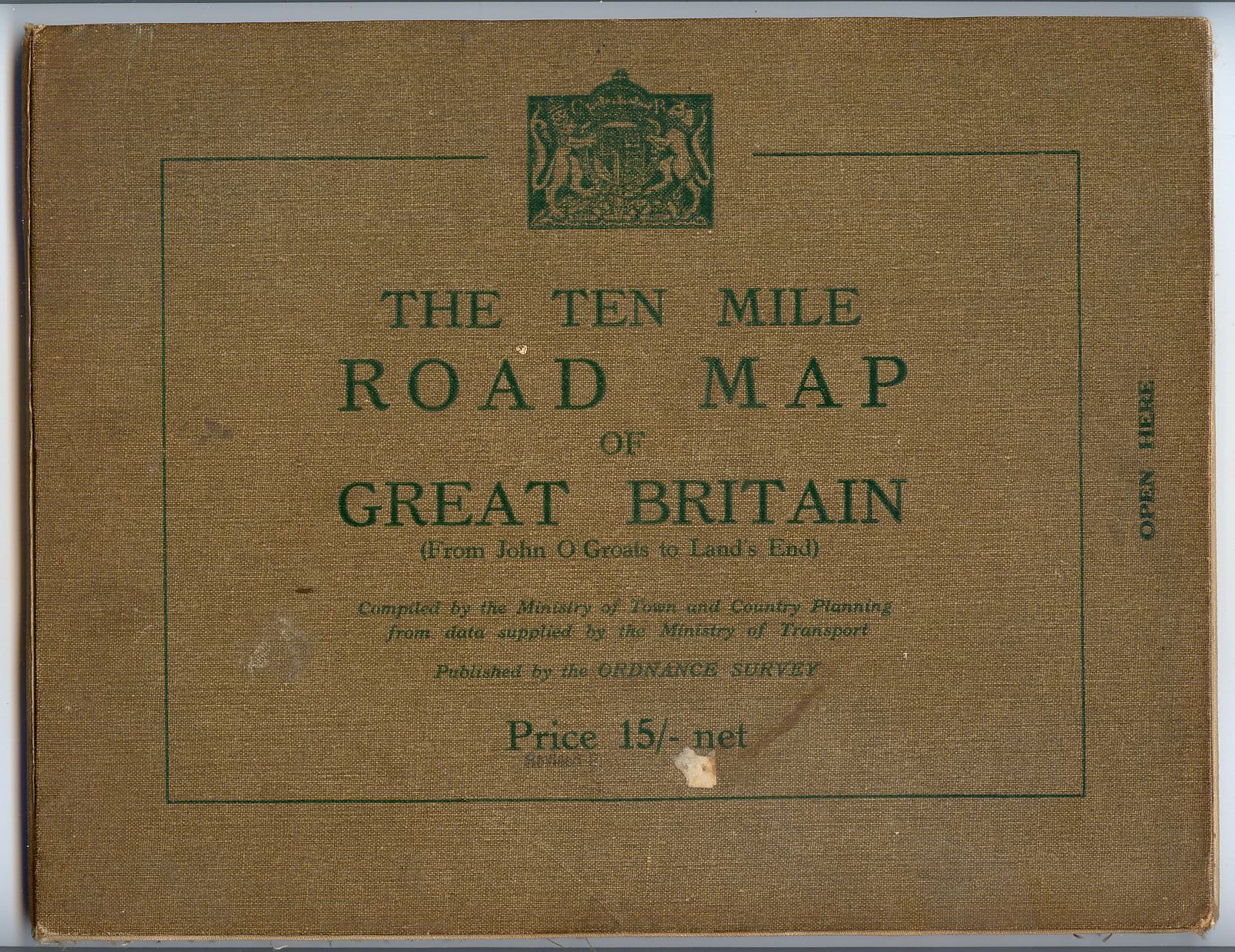
96.1.a.3 Buff card “Ten Mile” Map of Great Britain, 1955 [published 1956]/1958-1960
- [a] 139x215mm (Standard size). 3970 (Paper map). Arms of GVIR no initials. "Published 1956"
- [b] A/* 1960 Arms of EIIR. Text added under "Published 1955"


96.1.b Scottish lion rampant One-inch Scotland Popular Edition (with National Grid), 1945
- [a] 117x204mm 2246 (11/47) KA-S3 "Popular Edition" in large print, "SHEET". (See Andrews, Sheetlines 84.p33-41)
- [b] 118x208mm 2249 (5/47) KA-S4 "Sheet"
- [c] 116x212mm 2351 (1/53) KA-S5 "Popular Edition" in small print
- . [d] 120x208mm 2352 (1/53) KA-S6 GR deleted. [e] 117x205mm. 846/cr. Outline.


96.2 Blue border 96.2.a Long format Quarter-inch England & Wales/Scotland Fourth Edition (National Grid), 1945. In letterpress: Martin’s hand-lettered original was never used
- [a] 127x318mm (Standard size) 20046/Cr. Top left blank, no "Sheet"
- [b] 20046/Cr. "England & Wales" top left, "Sheet" added.
- [c] 20046/Cr. Town maps 1948. "England and Wales" top left.
- [d] 2034 Town maps 1948. "England and Wales" in different type, "(Fourth Edition)" above "WITH NATIONAL GRID"


- [e] c (1952) Town maps 1948. GR deleted.
- [f] B (1952) Town maps 1948. "England & Wales/Scotland" top left
- [g] 5046. "Scotland" - top left.
- [h] 5046. "Scotland" in small type, - deleted.


- [i] B/ (1957) Town maps 1948. GR deleted, "(Fourth Edition)" above "WITH NATIONAL GRID"

96.2.b Standard format
96.2.b.1 Buff card Roads, 1956; cover title The Ten-Mile Road Map of Great Britain
- [a] 138x214mm (Standard size). A 1956. (Cloth map). Arms of GviR but without initials.
- [b] A 1956
- . [c] A 1956. Arms of EIIR, Price ammended.


96.2.b.2 Cream card Isles of Scilly [Two-inch Special District (Relief) Map, 1933], 1959 [17] 117x196mm 3261 Royal arms of EIIR .Title on spine.

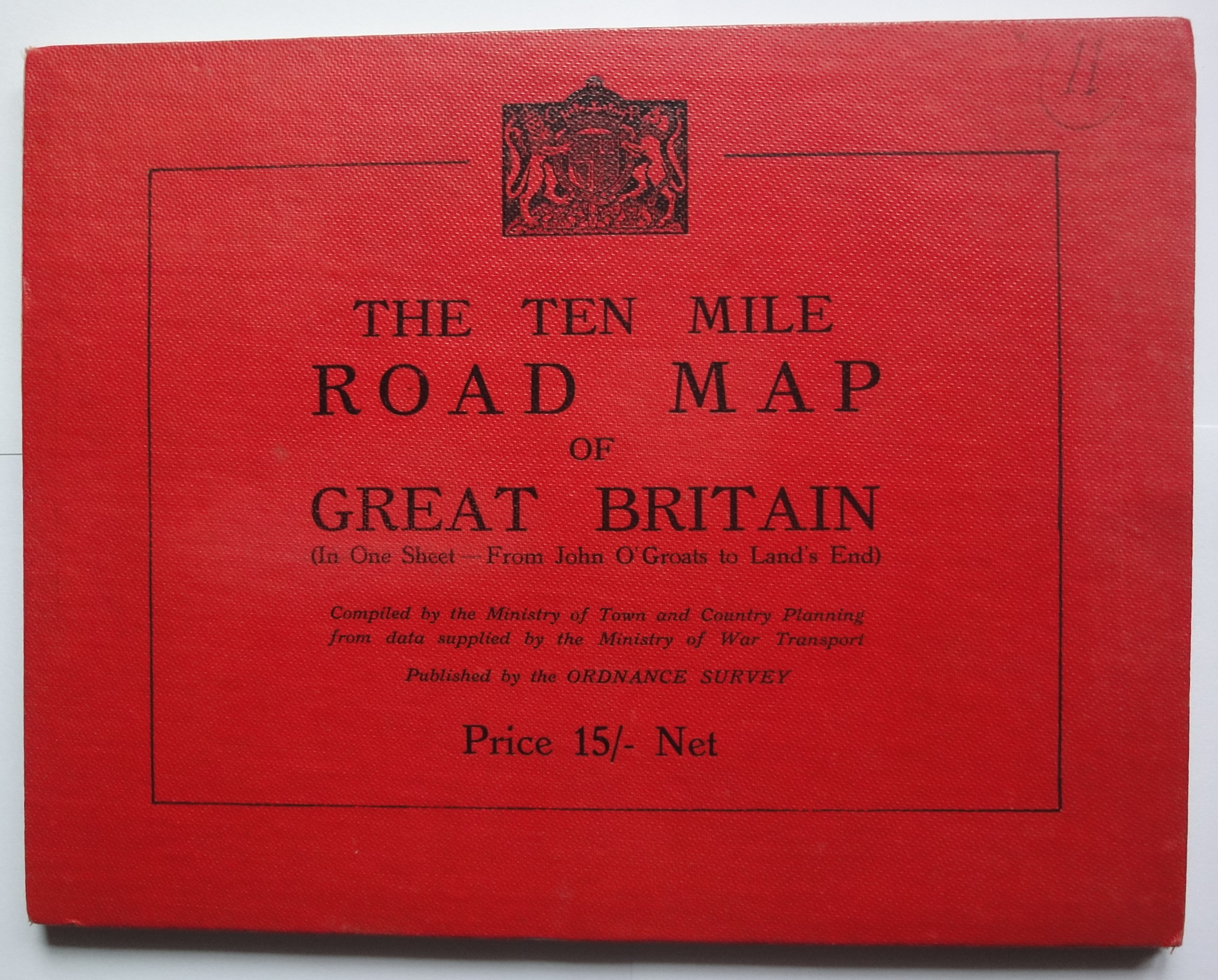
96.3 Brown border Roads, 1946; cover title The Ten-Mile Road Map of Great Britain Throughway Map of London [One-inch map] Printed Back to Back with Central London [Three-inch map]; publication in 1947 cancelled
- [a] 137x211mm (Standard size)(Cloth map) 25046 Also seen without the word "War".
- [b] 25.046.
- [c] 3817 Textual changes under SHEET
- [d] 3817 GR deleted.


96.4 Olive border
The Lake District [One-inch Tourist Map, 1925], 1947 [17]
122x214mm 20045/Ch. GR.The olive border extends to the edges of the cover. No title on spine. The same map as H.37 Benderfold.

Jersey [Two-inch map, 1933], 1947 [17]
- [a] 115x195mm 5000/34. GR, (Cloth) under Price statement. No title on spine.
- [b] (Cloth) included in Price statement.
- [c] No GR. Olive bars above and below "Fully Coloured". Text rearanged,"Net" introduced.


Guernsey [Three-inch map, 1934], 1947 [17]
- [a] 115x198mm 1934. GR. No title on spine. (Dissected map have hinged covers 118x203mm)
- [b] No GR. Olive bars above and below "Fully Coloured". Text rearanged,"Net" introduced.

Isle of Man [One-inch England & Wales Second War Revision sheet 17, 1942], with Cassini Grid, c.1948 [17]/with National Grid, 1950
- [a] Cassini Grid.
- [b] National Grid.


96.5 Green border Guernsey [Three-inch map, with Universal Transverse Mercator Grid], 1958 120x197mm 1958. Royal arms of EIIR .Title on spine.

One-inch Tourist Map Based on Great Britain New Popular Edition material
97 Loweswater and Carling Knott AF The Lake District, 1948; a photograph from The English Lakes (London, 1948, plate 71). Five of the original’s seven sheep were deleted, but two were reinstated later. Also considered was a view of Blea Tarn
- [a] 215x133mm glazed. 3271 (1948) Two sheep. Paper map with smaller title on spine, cloth as [b].
- [b] 215x136mm un-glazed, also glazed. 3631 (1951) Four sheep.Cloth map with bolder title on spine, paper as [a].


Post-war Ordnance Survey of Great Britain standard designs
The first post-war designs for Great Britain map covers and Ordnance Survey publicity material were the results of internal staff competitions. Those used or developed for use coincidentally featured graduated parallel lines or borders, usually black, separating the map title panel from the background colour. Reynolds Stone’s new Royal and Scottish Arms for Queen Elizabeth II were incorporated in 1956
98 Six lines, with index map CIV 1:25,000 Provisional Edition
98.1 Black and blue on buff Series sheets [cloth/paper maps], 1945; several minor design changes ensued
- [a] 119x216mm 10046 (11/46) "Price _ _" under "NATIONAL GRID"
- [b] 119x216mm 10046 (12/46) "PRICE _ _" In bottom blue panel
- . [c] 119x228mm (Standard size) A (1/48) "Price _ _" in black. Longer cover allows map fold to be above legend not through map face.
- [d] A (2/48) Title on spine. No publication date.


- [e] B (7/48?) "NATIONAL GRID" in black above bottomblue panel with "PRICE _ _" uncoloured.
- [f] A (4/50) "Revised Price 4/6 net" stamp, "3/-" barely obscured.
- [g] A (7/48) Revised price in black to sides of ornately obscured origional. [h] B 1950. "Price _ _" in black above bottom blue panel with "NATIONAL GRID" uncoloured.


- [i] "Printed _ _,Chessington,Surrey,1953" "Sheet SH93 (23/93)"

98.2 Black and blue on cream Series sheets [paper maps], 1950 [17]
- [a] 121x227mm (Standard size) 15046. (8/46) "SHEET"
- [b] B (8/51) "Sheet"
- [c] B (2/52) Simplified royal arms. Alpha-numeric sheet number introduced.


99 Five lines, stepped SPR Other Great Britain series sheets
99.1 Black and red One-inch Seventh Series, 1952. The length of cover extended by 20mm, 1960 [17] [11]
- [a] Square-Corner.bmp---125x196mm (Short,Standard size) 4010 (12/52) Square corners.Simplified arms of GviR. (See Andrews/Wheeler, Sheetlines 70.p11-21)
- [b] A (11/53) Rounded corners. Note taller lettering on spine for cloth map.
- [c] A/ (1957?) Arms of EiiR.
- [d] A (3/56) Scottish arms of GviR.


- [e] 126x216mm (Tall,Standard size).No secondary print on sheet106.A// 1960.
- [f] A/ 1959. Serif spine title.
- [g] B 1961 Thin sans serif spine title.
- [h] A/ 1960 "One-Inch" replaces "1"7th Series" on spine.
![]()


- [i] B 1961 Spine title reversed, now matching front cover.
- [j] B 1963 Price and style statement separated and moved to bottom red panel.
- [k] A 1956 Scottish arms of GviR. Serif spine title.
- [l] A 1956 Thin sans serif spine title.


- [m] A/ 1962 Scottish arms of EiiR.
- [n] A// 1963 "One-Inch" replaces "1"7th Series" on spine.
- [o] A/ 1960. Spine title reversed, now matching front cover. Price and style statement separated and moved to bottom red panel.
- [p] B 1963 White background, Laminated. Arms of EiiR.
- [q] A 1961 White background, Laminated. Scottish arms of EiiR.


99.2 Black and olive Half-inch Provisional Edition sheet 51, 1956 Half-inch Second Series sheet 36, 1958; sheets 28, 39, 1961
- [a] 126x206mm (Standard size) A 1958 Also with price as [d].
- [b] A 1956 No revision dates, "PUBLISHED 1956" under sketch.
- [c] A 1961
- [d] A 1961 Also paper, price as [c].


99.3.a Black and blue on buff Quarter-inch Fifth Series [1:250,000] sheet 10, 1957
126x196mm A 1957 Serif spine title, with "1/4" 5th. Series".

99.3.b Black and blue on cream Quarter-inch Fifth Series [1:250,000] series sheets, 1960 [17]. [A few [2]]
- [a] 127x195mm (Standard size) B 1962 Thin sans serif spine title, with "Quarter-inch", (reversed from H.99,3a). Price/style under title. Scottish sheets with same Royal arms.
- [b] A 1962 Price and style statement separated and moved to bottom blue panel.


100 Five lines, landscape format ?SPR Great Britain Special Maps
100.1.a Black and red One-inch Tourist Maps:
- [a] The Peak District, 1957 215x136mm A 1957 Serif spine title reading top to bottom.
- [b] A// 1960 Note same size but less ornate type faces.

- [c] The Lake District, 1958 212x136mm B// 1959.
- [d] 212x126mm B/// 1960. Note smaller size and less ornate type faces.

- [e] Wye Valley and Lower Severn, 1961 [e] 214x127mm A 1961

- [f] North York Moors, c.1961 [17] 212x126mm A/ 1958

- [g]212x136mm A 1959 Scottish arms with "ORDNANCE SURVEY" below.

- Loch Lomond and the Trossachs
- [h] 211x126mm A 1961.

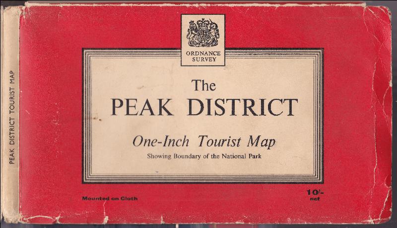
100.1.b The Royal Arms in frame The Peak District, 1963, and the other One-inch Tourist Maps, 1963 [17].
- [a] 214x127mm (Standard size) 1963 B Thin sans serif spine title reading top to bottom..

- [b] 1963 B. Style bottom left, price bottom right.Spine title runs bottom to top.
- [c] A// 1963 Price/style centre bottom. Spine title runs top to bottom.
- [d] A// 1963 Style bottom left, price bottom right.Spine title runs bottom to top.

- [e] B//// 1963 Also B/// 1960. with price/style as single central line, and spine title as [b].

- [f] A 1961

- [g] A 1961 Scottish arms with "ORDNANCE SURVEY" under but outside frame.

- Lorn and Lochaber cover was renamed Ben Nevis & Glen Coe, 1964
- [h] 212x127mm (Standard size) A/ 1959 Price/style centre bottom. Spine title runs bottom to top.
- [i] A/ 1959 Style bottom left, price bottom right

100.1.c Portrait format North York Moors [One-inch Tourist Map], 1958
135x212mm A 1958 Also "Price(paper) - Six Shillings Net"

100.2 Red Welsh dragon and blue Wales and the Marches [Quarter-inch Fifth Series Special Sheet], 1959 [11] /1963
- [a] 216x136mm Unlaminated. A 1959. Also B 1963 "Price(cloth)Nine Shillings Net"
- [b] Laminated. A 1959.

100.3.a Black and olive Half-inch Provisional Edition/Second Series sheets 28, 36, 39, Greater London [43], 51 in Half-inch District Map covers, 1962 [17]
- [a] Canterbury 213x125mm (Standard size) A 1956 Serif spine title reading top to bottom.
- [b] London A 1962 Also "Price(cloth)Seven Shillings & Sixpence Net" [c] Snowdon A 1961
- [d] Birmingham A/ 1958.

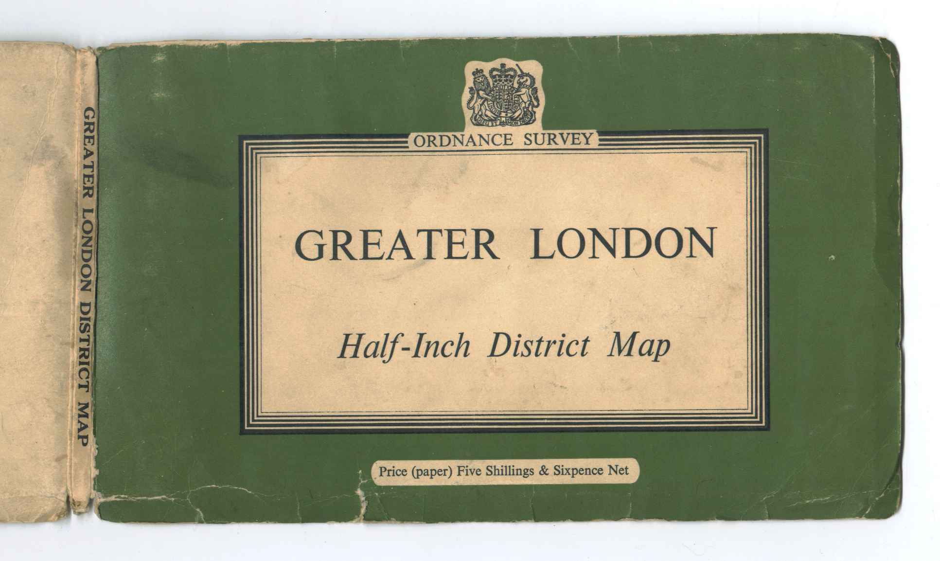


100.3.b The Royal Arms in frame The same Half-inch sheets in District Map covers, 1963 [17]
- [a] 212x126mm (Standard size) A 1961 Thin sans serif spine title reading bottom to top.
- [b] A 1961 Also with Price/style centre bottom.(as 100.1b,[a])


Other contemporary covers 101.1 Ansell-fold, yellow boards The Ten Mile Road Map of Great Britain, 1946 [9]
257x201mm 25.046. Arms of GvR.

101.2 Ansell-fold, khaki boards The Ten Mile Road Map of Great Britain, 1948 [17] [9]
- [a] 259x201mm 3817 Arms of GvR minus v
- [b] 259x201mm 3817 Arms of GviR.

101.3 Ansell-fold, red boards The Ten Mile Road Map of Great Britain, 1944 [9]
259x200mm. 1944. GB sheets 1 and 2 Administrative areas.
102 Green on buff card Richmond Park, 1949; St James’s & The Green Parks,1953; Greenwich Park, 1954
- [a] 123x247mm Long format. L.185.a 1949,Note "Price - - - Mounted, 4s 6d" no "net". Also paper 3s. 6d.
- [b] 124x249mm Long format. L.403.a 1949,Reprinted with corrections 1951. Note different price statement. Also (paper) 3s. 6d.net
- [c] 123x203mm Short format. L517 1953.
- [d] 123x215 L 583 1954. Arms of GviR


103 Green on paper Richmond Park, 1962 [2]; Bushy Park & Hampton Court Gardens & Park, 1964 [2]
- [a]119x218mm 776 1964.
- [b] 119x222mm 775 Revised 1968. "Department of the Environment."
- [c] "Ministry of Public Buildings and Works."


104 Green check Regent’s Park & Primrose Hill, 1961 115x217mm

105 The Palm House RASH The Royal Botanic Gardens Kew, 1962 [2]/1963 [2]/1972 [2]/1974 [2] 118x215mm 1968.

106 Pink panels Ministry of Transport Through Route Map of London Area [One-inch map], 1955 [17] 127x313mm 1953.

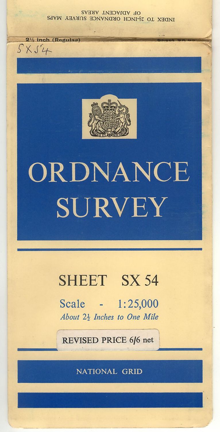
107 Blue panels 1:25,000 Provisional Edition, 1955 [17]/First Series, 1956,
- [a] 121x228mm (Standard size) C 1947. Arms of GviR, SHEET numeric, no title on spine.
- [b] C 1952. SHEET alpha/numeric. (numeric) under.
- [c] C 1955. (numeric) deleted. Spine title right to left.
- [d] B/ 1958. Cover hinge 9-60-W Arm of EiiR.
- [e] B 1961. Cover hinge 7-63 M Price increase.
- [f] B/ 1960. Cover hinge M 2-64 Spine title left to right.
- [g] B 1959. Cover hinge M 5-64 Spine title "(Regular)". Only for sheets SX45-47,54-57,64-67.
- [h] C 1958. Cover hinge M 12-64 Price increase.


Ilfracombe [1:25,000 Provisional Edition sheet 856], 1960 [2]. Renamed Ilfracombe and Lundy c.1967 [17] [2]
- [a] 115x188mm A 1960.
- [b] A 1960.

FORWARD to Ordnance Survey House Style, 1963