
FORWARD to Official Leisure Maps / 1:10,000 District and Neighbourhood Maps
Reference numbers in square brackets and artists' initials are explained here
The new Ordnance Survey colophon by Reeves, a north-pointing crossed arrow between the letters O and S, representing both a bench mark and a magnetic needle, was developed by the Central Office of Information and made its first appearance on the Ordnance Survey Publication Report for January 1969. It was gradually incorporated into all map cover designs and remains in use at the time of writing. A white frame surrounds location map or illustration
Dated covers, various colours 1:625,000 Route Planning Maps [Routeplanner from 1980]
127 Great Britain diagram 1969-1974 [published annually 1968-1973]
- [a] 126x214mm Laminated (Standard size) F
- [b] F
- [c] G
- [d] G
- [e] Dual price H
- [f] H
- [g] Decimal price for pair. J
- [h] J
- [i] Decimal price individual. K
- [j] K also K/*
- [k ]L
- [l] L


128 Motorway junction 1975-1979 [published annually 1974-1978]
- [a] 126x214mm (Standard size) Double sided map North/South M
- [b]N
- [c]P
- [d]Q
- [e]R


129 Triumph Dolomite 1980 [published 1979] S

130 Jaguar XJ Coupé 1981 [published 1980] T

131 Austin Metro 1982 [published 1981] U

132 One colour covers Series sheets, the covers of various dimensions, usually with location map
132.1 Red One-inch Seventh Series, 1969 [17]
- [a] 127x213mm (Standard size) (See Andrews/Wheeler, Sheetlines 70.p11-21) Blank ready for secondary printing. Sheet 99 "HULL" B/ 1962
- [b] Red index on back cover. B 1965
- [c] Pink index on back cover. C 1970
![]()


132.2 Dark blue Quarter-inch Fifth Series, 1970 [17]
- [a] 127x195mm (Standard size) Dual price, light blue back index. B 1967
- [b] Decimal price label. B/* 1969
- [c] Decimal price, dark blue back index.


132.3 Blue, no location map 1:25,000 First Series, 1970 [17] [2]
- [a] 118x238mm (Standard size of folded map) The map edition codes and dates cannot be trusted to date the covers. Dark blue. B/ 1958
- [b] Flat sheet,the blue panel 123x247mm Light blue Blank ready for secondary printing. SO90 B/ 1970
- [c] Secondary printing on folded light blue B///** 1983
- [d] Secondary printing in green. May 1965
- [e] Secondary printing in green, price in black (third printing?). May 1965


132.4 Green 1:25,000 Second Series, 1971 [17] [Pathfinder Series from 1980]
- [a] 127x227mm Laminated (Standard size) "Second Series" above sketch Three lines of text under sketch. Price printed with sheet detail. A 1973
- [b] Price as later additional printing. A 1970
- [c] Two lines of text. A/ 1968
- [d] Un-laminated A 1976
- [e] "Pathfinder Series" above sketch A 1978


132.5 Blue 1:25,000 Provisional Edition Isles of Scilly, 1972 [17] [First Series on cover]
127x220mm A/ 1969
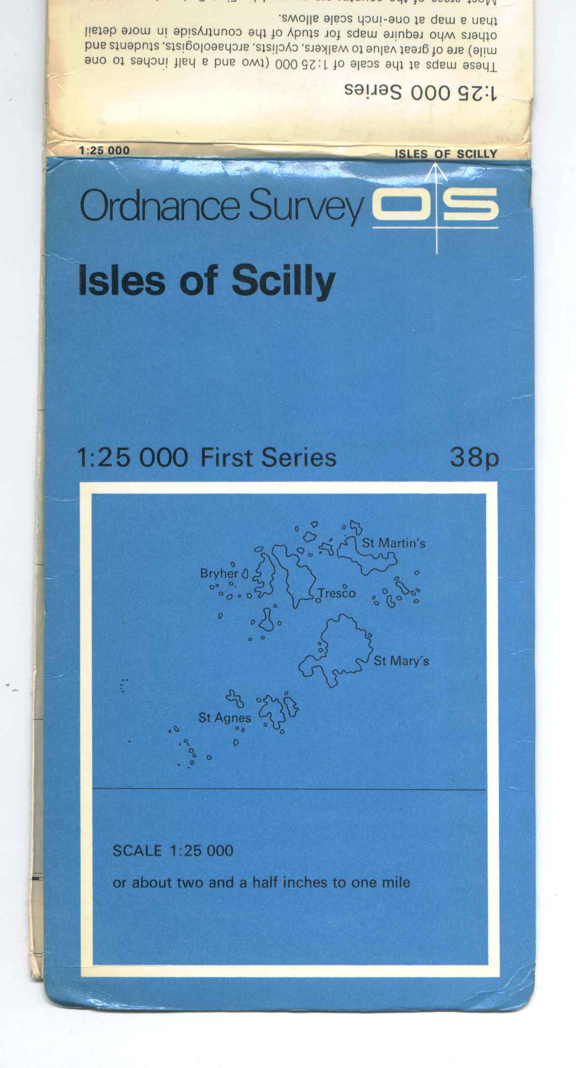
132.6 Light blue 1:25,000 First Series Isles of Scilly, 1974
126x220mm A// 1974.

132.7 Magenta 1:50,000 First Series/Second Series, 1974 [Landranger Series from 1980]
133x225mm Laminated (Standard size) See also 301.1a
- [a]"First Series" above sketch A 1974
- [b] "National park" A 1974
- [c] "Forest Park" A 1976
- [d] "Second Series" above sketch A 1976
- [e] "National Park" A 1976


- [f] Unused (proof?) British Gas NW.
- [g] Second Series A//** 1986.


Local views on black covers One-inch Tourist Maps, unless listed otherwise
133 Ashness Bridge, Derwent Water Lake District, 1970 [17].
127x213mm Standard size for 133-136 & 138-146 No text under illustration. Price as integral printing. C/* 1970 The illustration was printed back to front!

134 Blea Tarn and Langdale Pikes Lake District, 1971 [17]
Text under illustration. Price as integral printing. C///*** 1974 Also C/* 1970 50p

135 Winnatts Pass near Castleton Peak District, 1970 [17]
- [a] No text under illustration. Price as integral printing. B/* 1970 Also 50p,55p and B//* 1972 55p
- [b] Text under illustration. Price as secondary printing. B////*** 1979 Also £1.60 and B///** 1976 £1.20

136 St Hilda’s Abbey, Whitby North York Moors, 1970 [17]
- [a] No text under illustration. Price as integral printing. B/* 1970 Also priced at 55p and B//** at 55p
- [b] Text under illustration. Price as secondary printing. B////**** 1978 Also B//** at 58p, B///*** 1976 at 95p and B5/* at£1.40

137 The Tower of London NJ Greater London [One-inch Special Map], 1971
126x232mm Laminated No text under illustration. Price as integral printing. B 1971 Also priced at 50p

138 St David’s Cathedral Wales and the Marches [Quarter-inch Fifth Series Special Sheet], 1971/1976
- [a] No text under illustration. Price as integral printing. C 1971 (What is obscured at repricing?)
- [b]Text under illustration. Price as secondary printing. C 1971 Also D 1976 95p

139 New Forest ponies New Forest, 1972 [published 1973]
- [a] No text under illustration. Price as integral printing. B 1972
- [b] Text under illustration. Price as secondary printing. B 1972 Also priced at 65p
- [c] With Tourist Information B//** 1982


140 Harlech Castle Snowdonia National Park [Half-inch map], 1973 [17]
- [a] No text under illustration. Price as integral printing. A//* 1973
- [b] Text under illustration. Price as secondary printing. A//* 1973 Also A///** 1976 £1.40 and A/////**** 1981 £2.20

141 Tarr Steps Exmoor, 1973
- [a] No text under illustration .Price as integral printing. B
- [b] Text under illustration. Price as secondary printing.

142 The Three Sisters, Glen Coe Ben Nevis & Glen Coe, 1973 [17]
A////*** 1975 Also A///** 1972 65p & A/////**** 1980 £2.00

143 Hay Tor Dartmoor, 1973
- [a] No text under illustration.Price as integral printing. B
- [b] Text under illustration. Price as secondary printing. B//**

144 Granite rocks and stag Cairngorms, 1973 [17]
A/// 1975 Also £1.40

145 Trossachs Pier, Loch Katrine Loch Lomond and the Trossachs, 1974 [17]
- [a] No text under illustration.Price as integral printing. B/* 1973 In the OS Map Catalogue for 1974 the cover is shown with the illustration reversed
- . [b] Text under illustration. Price as secondary printing. B//** 1976 Also B/* 55p blocked out 65p along side (see 138 [b])

Birds on brown/yellow covers First/Second Series 1:25,000 Outdoor Leisure Maps
146.1 Ring ousel, brown HT The Dark Peak, 1972 [8]
- [a] A/ 1973 Also cc1972 95p(integral)
- [b] Signature re-instated. A//* 1977 Also A/ 1973 original price (£1.00) blanked out £1-10 printed above.
- [c] water resistant A///** 1980


146.2 Ring ousel, yellow HT The Dark Peak, 1983 [published 1984] B 1984

147 Curlew, brown HT The Three Peaks, 1973
A/* 1978 Also A//** 1982 and A 1973 original price blanked out £1-10 printed above.

148 Capercaillie, yellow HT High Tops of the Cairngorms, 1974; renamed Aviemore and the Cairngorms, 1982
- [a] A/* 1978
- [b] Title change, cover and map. A//** 1982


149.1 Raven, brown HT The English Lakes, 1974 – 4 sheets [NW, NE, SW, SE sheets [8] ]
- [a] A/* 1975
- [b] A//** 1979 Price label.
- [c] A//** 1979 Also A 1974 £1-00(integral)
- [d] water resistant A//* 1979


- [e] A//* 1979 Also A 1972 £1-00(integral) and A/ 1975 £1-95
- [f] A///* 1979 Also A//*1979
- [g] A///* 1974 Price label.


149.2 Raven, yellow HT The English Lakes, 1982 – 4 sheets
- [a] Single line of text above illustration. B 1982
- [b] Two lines of text above illustration. B/ 1982
- [c] Single line of text above illustration. B 1982
- [d] Two lines of text above illustration. B/ 1982


 [
[
- [e] Two lines of text above illustration. B 1982
- [f] Single line of text above illustration. B/ 1982
- [g] Single line of text above illustration. B 1982


150 Golden eagle, yellow HT The Cuillin Hills/The Torridon Hills, 1975 [8]
- [a] A 1975 Also with integral price £1-90
- [b] 126x234mm, A 1975. Water resistant.


151 Skylark, yellow HT Brighton and Sussex Vale, 1975
Integral price A 1975

152 House martin, brown HT Malham and Upper Wharfedale, 1975 [published 1976] [8]
- [a] A/* 1978
- [b] water resistant A/* 1975


153 Buzzard, brown HT Brecon Beacons National Park, 1976 – 3 sheets
- [a] A 1976
- [b] A 1976 Also A/* 1981 £2-35
- [c] A 1976


154 Kingfisher, brown HT Wye Valley and Forest of Dean, 1977 [8]
- [a] Single line of text above illustration. A 1977
- [b] Two lines of text above illustration. A////*** 1984
- [c] water resistant A//* 1981


155 Dartford warbler, yellow HT Purbeck
, 1977 A 1977

156 Jay, brown HT Snowdonia National Park, 1977 – 4 sheets [2 published in 1978]
- [a] A 1978
- [b] A 1977
- [c] A 1978 Also A/ 1978 £2-35
- [d] A 1977


157 Dipper HT Unused drawing for Snowdonia National Park: Conwy Valley, 1977
158 Oystercatcher, yellow HT South Devon, 1978 A 1978

159. 1 Twite, brown HT South Pennines, 1978
Single line of text above illustration. A 1978

159.2 Twite, yellow HT South Pennines, 1984
Two lines of text above illustration. B 1984

160 Hobby, yellow HT New Forest, 1979 [8]
- [a] A//** 1982
- [b] water resistant A 1979


161 Cormorant, brown HT Snowdonia National Park: Cader Idris/Dovey Forest, 1979 [8]
[a] A 1979
[b] water resistant A 1979


162 Wheatear, yellow HT The White Peak, 1980
- [a] Single line of text above illustration. A 1980
- [b] Two lines of text above illustration. A 1980


163 Puffin, yellow HT Isles of Scilly, 1982 [2]
115x182mm Direct A 1982

164 Red grouse, yellow HT North York Moors, 1982 [published 1983] – 2 sheets
- [a] A 1982
- [b] A 1982


165 Whinchat HT Unused drawing for Dartmoor, 1984. Superseded by photographic cover
166 Mute swan HT Unused drawing intended for the unpublished Thames Valley
FORWARD to Official Leisure Maps / 1:10,000 District and Neighbourhood Maps